MOHID Studio
The MOHID Modelling System stands out for its integrated approach. Used by hundreds of professionals worldwide MOHID Modelling System has turned into one of the most reliable set of numerical models for the water cycle.
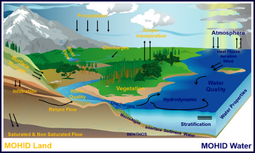
MOHID Modelling System can be used to simulate a wide range of processes occurring in watersheds, rivers, groundwater, lakes, estuaries, coastal areas and oceans.
The process based, spatially distributed numerical models included in the MOHID Modelling System have a large spectrum of application, like for example, construction work, water quality management and risk assessment. Core numerical models are MOHID Land and MOHID Water.
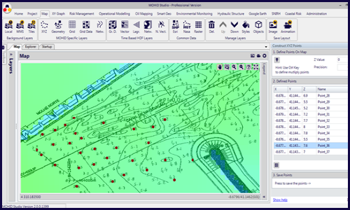
MOHID Studio overcomes the complexity of running the models of the MOHID Modelling System by integrating them into a user friendly, graphical interface. Composed by a set of functional modules and tools, MOHID Studio allows performing all tasks related with model implementation, validation, execution and result visualization.
MOHID Studio contains a lot of features and tools which help the users prepare all the necessary data to set up model simulations, including grid generation, initial and boundary conditions. Numerical models can be launched directly from the user graphical interface and results can be visualized using a set of integrated visualization tools. Data can be interchanged with a wide range of standard formats, like EXCEL, ESRI Shapefiles and KML. A set of plugins extent even further features found in MOHID Studio.